


Description
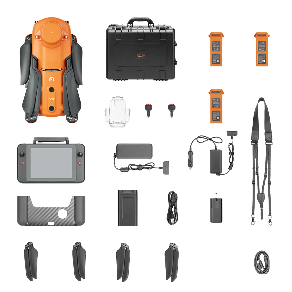
6K RTK (V3) Rugged Bundle
- New 2022 RTK for centimeter-level positioning
- Supports Post-Processing Kinematic (PPK)
- No GCP required
- 3rd-party base station support
- Multi-NTRIP profile saving
- Multi-battery missions
- 360� obstacle avoidance
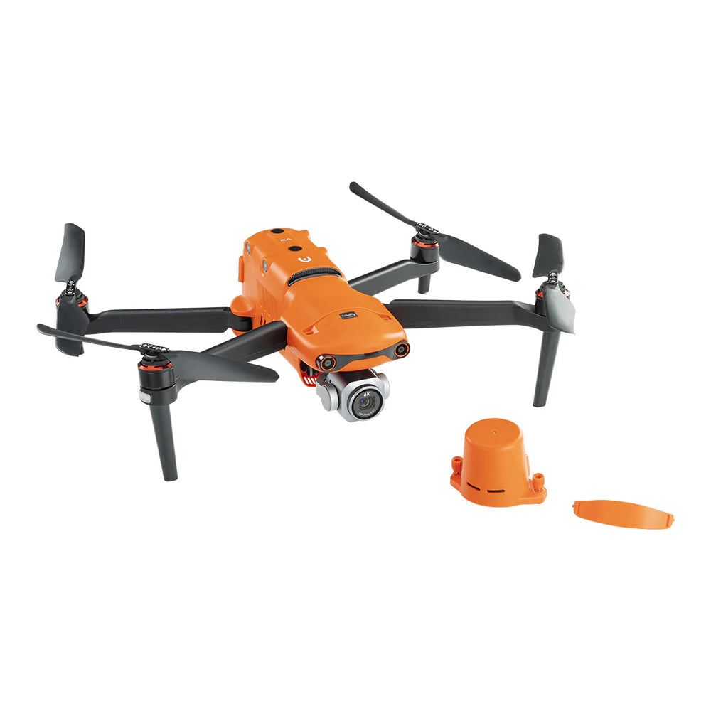
- 1-inch ultra-sensitive sensor
- 38-minute maximum flight time
- No geo-fencing
-
15-km maximum transmission range

Autel EVO II Pro 6K RTK V3 – Precision and Performance Elevated
Professional-Grade Accuracy with RTK
The Autel EVO II Pro 6K RTK V3 builds on the strengths of its predecessor, now equipped with an upgraded 2022 RTK module for centimeter-level accuracy. Within just three minutes, it delivers real-time RTK positioning, while also supporting PPK (Post-Processed Kinematics) to ensure data reliability even in low-connectivity areas. It integrates seamlessly with NTRIP RTK networks and RTK base stations and records essential flight data such as camera exposure settings and satellite observation logs for advanced post-flight analysis.
Superior Imaging for Any Environment
Powered by a Sony 20MP 1-inch CMOS sensor, the EVO II Pro 6K RTK V3 captures stunning 6K video, 6K hyperlapse, and detailed stills with adjustable aperture (f/2.8–f/11). Its Moonlight Algorithm 2.0 enhances clarity in low-light conditions with ISO up to 44,000, while HDR (High Dynamic Range) ensures balanced exposure across highlights and shadows. This makes it equally capable for cinematic applications and professional surveys.
Optimized for Professionals
-
Centimeter-level accuracy with RTK and PPK modes
-
NTRIP + RTK base station support for versatile deployments
-
6K video and 20MP stills with low-light optimization
-
Adjustable aperture & ISO flexibility for creative or technical needs
-
HDR technology for dynamic detail capture
In summary, the EVO II Pro 6K RTK V3 combines unmatched precision, advanced imaging capabilities, and reliable flight performance, making it a leading solution for mapping, surveying, and professional cinematography.

Autel Robotics EVO II Pro 6K RTK Rugged Bundle V3
Maximum Performance, Complete Safety
The Autel EVO II Pro 6K RTK V3 is built for professional-grade aerial mapping, inspection, and cinematic use. With SkyLink 2.0 transmission supporting up to 15 km range, 38 minutes of flight time, and advanced triple-band communication (900 MHz / 2.4 GHz / 5.8 GHz), it ensures long-range, interference-resistant performance. Its 19 onboard sensors create real-time 3D environmental models, enhancing safety with intelligent obstacle avoidance.
Precision Aerial Mapping
The integrated RTK module delivers centimeter-level positioning (horizontal: 1 cm + 1 ppm; vertical: 1.5 cm + 1 ppm) for surveying, agriculture, and construction. It supports RTK base stations, NTRIP networks, and PPK post-processing, reducing or eliminating the need for GCPs. Mapping tools in the Autel Explorer app include multi-battery mission planning, photo replication, polygon/rectangular zones, and double-grid coverage.
Smart Controller SE + SkyLink 2.0
This rugged bundle includes the Smart Controller SE, featuring a 7.9-inch QHD screen, 8-core processor, and 4.5 hours of runtime. With IP43 protection, wide temperature tolerance (-4°F to 122°F), and Android OS support for third-party apps, it’s ready for any mission.
Additional Highlights
-
6K resolution camera with up to 16x digital zoom (3x lossless)
-
Level 8 wind resistance for stable flight
-
High ISO (up to 44,000) for low-light shooting
-
Live Deck 2 compatibility for broadcasting
-
No geofencing restrictions for instant deployment
The EVO II Pro 6K RTK V3 combines power, accuracy, and flexibility, making it the go-to drone for professionals in mapping, inspection, and creative industries.
Short Description:
Autel Robotics EVO II Pro 6K RTK Rugged Bundle V3 – Professional mapping drone with centimeter-level RTK accuracy, 38-min flight time, SkyLink 2.0 transmission, Smart Controller SE, and advanced obstacle avoidance.
SKU: 102001519
Manufacturer: Autel-Robotics
UPC: 889520204484
Compatible with: Autel EVO II
Open Box: No
Payment & Security
Your payment information is processed securely. We do not store credit card details nor have access to your credit card information.